NGĀ TAPUWAE O TOI WALKWAY | TOI’S TRACK
Click here for a virtual tour of Nga Tapuwae o Toi Walkways using Google Street View.
Nga Tapuwai o Toi Walkways:
- Whakatane to Otarawairere Bay, Ohope - Kohi Point Walkway
- Fairbrother Loop, Ohope
- Mokorua Bush Scenic Reserve - the Bird Walk
- Ohope Scenic Reserve
Google Street Map Views
- Whakatane attractions & activities


Ngā Tapuwae O Toi Walkway or Toi's Track. Is Whakatane's most scenic walking track. Translated as ‘the footprints of Toi' the 16 kilometres of walkways on the outskirts of Whakatane are accessible to most people, regardless of fitness, because they can be walked in sections or as one round trip. Nga Tapuwae o Toi visits three major scenic reserves and a historic reserve. In Ngati Awa oral tradition Toi was a great chief, descendant of the legendary voyager Tiwakawaka and founder of a great tribe. The walkway visits Toi stronghold Kapu-te-rangi overlooking Whakatane. The walkway crosses Kohi Point Scenic Reserve, Ohope Beach, travels through the Ohope Scenic Reserve pohutukawa forest, across remnants of native forest to the regenerating flora of Mokorua Bush Scenic Reserve.
You venture through native bush and our picturises beaches. There are lookout spots and benches along the way to take in the stunning views of Moutohorā (Whale Island), Otarawairere Bay and Ōhope Beach. Note: Otarawairere Bay is not accessible during high tide. Click here for tide times


More Information
Maps and closures
Make sure to check for closures and plan your walk around tide times.
Mokorua Gorge to Toi Pā
Time: 1 hr 30 min
Easy walking. This is the best starting point for the round trip. Walkers should head north from Mokorua Gorge along Commerce Street, turning right just before Pohatoroa (the Rock) to climb the escarpment steps leading to Hillcrest Road. Turn left onto Seaview Road to find the track leading to Kapu-te-rangi.
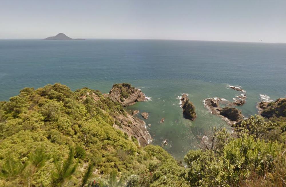
Soon after leaving the road, the track passes the head of Wairere Falls. After climbing through an area of attractive regenerating bush, Kapu-te-rangi is on the right. From this pā, continue north-east, the track follows the cliff top above Whakatāne, skirting a number of pā sites. Toward the tip of Kohi Point, the track emerges onto an area of low scrub and flax land and then follows the cliff tops to the south-east. Superb coastal views are obtained throughout this section, but for your safety please stay to the track.
Toi Pā to Ōhope Beach West End
Time: 2 hr
Easy walking. After rounding a headland, several tiered staircases lead down to Otarawairere Bay, a great place for a picnic, swim or a bit of fishing. Note: Otarawairere Bay is not accessible during high tide - check Whakatāne high tides (external site) on the Metservice website.
Access to the bay is also available via a track down from Otarawairere Road. To continue on the walk, pass this track and rejoin the walkway near the eastern end of the bay to cross the headland to Ōhope Beach.
Ōhope Beach West End to Ōhope Scenic Reserve
Time: 30 min
Easy walking. Walk along the beach to the bottom of hope Hill and West End Road intersection. Cross the road to Ōhope Scenic Reserve.
Fairbrother Loop Walk
Time: 1 hr
Easy walking. Soon after leaving Ōhope Beach, is the foundation of an old pumping station. Take the left fork for a pleasant uphill walk featuring a number of views over the forest and Ōhope Beach. At the intersection at the top of the loop carry straight on to finish the loop back at to where you started at the bottom of Ōhope Hill. Take the turn-off if you want to carry on with the Nga Tapuwae o Toi round trip.
Ōhope Scenic Reserve to Burma Road
Time: 1 hr
Easy walking. Take the same track as the Fairbrother Loop described above except at the top of the hill take the turn-off sign posted as Burma Road. This track pleasantly sidles along the side of a ridge and comes out at Burma Road.
Burma Road to White Horse Junction
Time: 45 min
Moderate walking. After crossing Burma Road, the track climbs steeply before entering private land. Here, sections of raised boardwalk make for an easy and charming walk through areas of native forest and wetland featuring large pukatea, tawa and puriri trees. Further on, the track meets the Mokorua Reserve walkway at the White Horse Drive Junction.
White Horse Junction to Mokorua Gorge
Time: 45 min
Some steep sections. The walkway traverses the stream valley a number of times before climbing the high ridge overlooking Whakatāne. It then follows the ridge down to a final steep descent to the walkway exit adjacent to the car park at the bottom of the gorge. This last section is locally known as the 'Bird Walk'.