The North Island can expect a pre-Easter battering from the remnants of ex-tropical Cyclone Fili.
But despite strong wind warnings and heavy rain watches in place, the worst should be gone for the long weekend.
In what MetService is predicting as an exclusively North Island event there are strong wind and rain watches or warnings in place from Northland down to Wellington.
Cyclone Fili is approaching New Zealand from the northwest and is expected to land on Tuesday.
It has been slow-moving just south of New Caledonia for the past couple of days. However, it is going to deepen and accelerate towards New Zealand later on Monday.
MetService meteorologist David Miller said there was potential for Cyclone Fili to cause some damage.
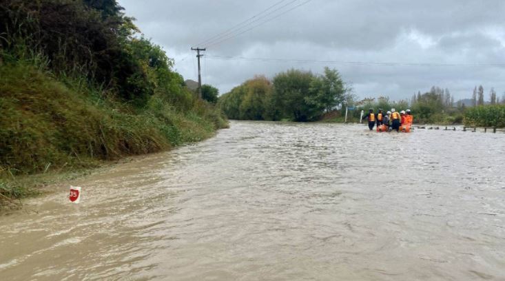
‘’Especially places like Gisborne, where any extra heavy rain at this point will be unwelcome. The heavy rain definitely has the potential to compound what they saw a couple of weeks ago.’’
Waikato, Waitomo, Taumarunui, Taranaki, Whanganui, Manawatū, Horowhenua, Kāpiti Coast, Wellington, Wairarapa, Tararua District, Taihape, Hawke’s Bay and Taupō are under a strong wind watch which may see southwest winds become severe gales at times.
‘’At this stage Waikato is not on a heavy rain watch or warning. There will be some rain starting tomorrow afternoon, there could be some heavy falls tomorrow evening, and then it should start easing during Wednesday as Fili starts moving away towards the Bay of Plenty.’’
Miller said that despite being declassified to an ex-tropical cyclone, Fili could still bring severe weather.
“Between now and midnight Tuesday the low is actually going to deepen further, which means the winds are going to be very strong by the time they get to New Zealand, hence why we have the wind warnings out.”
Those wind warnings cover the possible chances of dangerous winds for coastal areas from Northland to Hawke’s Bay.
While the South Island appears to be likely to be out of Fili's way, there is a heavy rain watch and warning for Fiordland and Westland.
“There is a standard front moving north over that area over Monday night into Tuesday morning.”
Miller said at this stage it looked as though Fili would clear away from the east of the North Island during Thursday.
‘’There could be another low coming down from the north this weekend, but it is still a few days away yet. Fili will have cleared the North Island by Thursday.’’
Coromandel residents are being encouraged to “prepare and hunker down” for ex-tropical Cyclone Fili.
Civil defence controller for the Coromandel Gary Towler said they were taking the warning from MetService very seriously.
“To get a warning more than 24 hours out from MetService is the trigger we have to take this one very seriously, and it could have significant impacts to the entire Coromandel Peninsula.”
He said they were in the process of getting things in place to protect people and property, and were having regular briefings with Waikato Regional Council and MetService.
‘’The roading contractors have to be well briefed and resourced as well as they can be. We need to remind the people how to stay safe and ensure they have adequate supplies to last for a couple of days if they are isolated.’’
He said there was a high possibility that power would be out for some time and once people were isolated, they would have to wait it out until the weather cleared before Towler’s team could offer assistance.
‘’It is about getting people to prepare for themselves, prepare their own properties, like securing outdoor furniture.
Prime Minister Jacinda Ardern visited the Tairāwhiti region on March 27 following flooding in the area.
“We are certainly putting the warnings out for people to prepare and hunker down.”
The Bay of Plenty civil defence team is working behind the scenes to make sure the region’s rivers and catchments can cope with increased rainfalls.
‘’From a public preparedness and safety point of view, the Easter weekend and start of school holidays means there are likely to be more people on the roads as well as visitors who might not be familiar with local hazards.
‘’We want to make sure everyone in the region recognises which locations may be at risk of flooding as well as associated risks like landslips, road closures.’’
People are being asked to keep an eye on the forecast.
‘’At this stage, we are not expecting that people in our region will need to evacuate but that could change. People who are planning to camp out over the next few days should keep a very close eye on warnings and think about a plan B,’’ a council spokeswoman said.
She said Cyclone Fili is tracking very similarly to the last ‘orange’ weather event a few weeks ago that saw heavy rain and wind the Bay, although their neighbours to the East took the real hiding
A reminder too that if you are Covid-19 positive and isolating not to stay in an unsafe place, if your house is damaged.
“Even if you are sick or isolating, the most important thing is to get yourself and your whānau to safety.”
Auckland City Council’s emergency management general manager, Paul Amaral, said they were monitoring the progress of Fili, so that teams could be ready to respond if needed.
‘’As always, we are reminding Aucklanders to keep up with weather forecasts and carry out any necessary pre-storm checks.
‘’This includes clearing gutters and drains on your property, securing loose items outdoors and – if you live in an area prone to flooding – checking your emergency plan is up to date.’’
He said they were expecting plenty of rain and high winds, so people should consider travel plans carefully and should not drive through floodwaters.
Fallen trees, blocked drains or debris on public property can be reported to Auckland Council using the online ‘Report a Problem’ tool. Visit www.aucklandcouncil.govt.nz for more.
Credit: Stuff.co.nz